Here is a copy of an article I wrote for the latest issue of Biodiversity Ireland, on why I record biodiversity.
Most days, when I am out and about, I take note of the wildlife I see and submit the details to the National Biodiversity Data Centre. In this way, I am an active biological recorder. As long as I document what species I see, when I see it, and where it was seen, then I have a valid biological record. I know that whether it is a fleeting encounter with a stoat crossing the road or a more detailed list of species for one of my favourite sites, the information I collect is valuable.
Value of one-off sightings
I know that recording one-off encounters with species like the stoat can help to build up a picture of its distribution in Ireland. The Irish stoat (Mustela ermine hibernica) is one of Ireland’s really special species, a near endemic to Ireland. Yet there is little empirical data on its distribution for it is an exceptionally challenging species to study. As part of the Atlas of Mammals in Ireland 2010-2015 project more than 1,100 sightings of Irish stoat have been submitted by people across the country, allowing us to better understand the species distribution in Ireland. And thanks to the online data portal, Biodiversity Maps, all of these observations of Ireland’s threatened and protected species are now freely available to local authorities and other land managers to improve the quality of their decision-making to assist nature conservation.
Recording common species
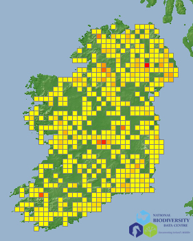
Periodically I also record the commoner species, for who knows what the future holds? I love seeing yellowhammer signing from telegraph poles near where I live in Kilkenny, but I know that they are rare or absent from other parts of Ireland. My father told of, in his youth, being deafened by calling corncrakes in north Kerry, a species long since gone from that region. Think of the value of having a detailed database of observations of this once common species so that we could present dramatic quantitative information on the impact that drainage and land management has had on this iconic species?
Contributing to large Atlas projects
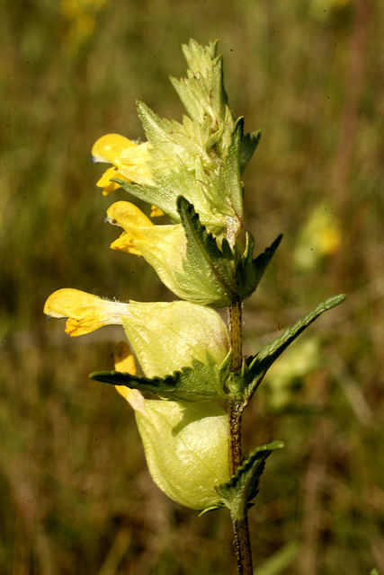
Being an unskilled botanist, I can probably identify only about 100 of our commoner plant species. But I also record these for I know the more I record, slowly the number of species I can confidently identify increases. And every little bit helps. At the moment fieldwork is under way for the Botanical Society of Britain and Ireland’s Atlas 2020 project, a huge project that aims to map the distribution of all plants across Britain and Ireland. Comparing the results of this Atlas with two previous atlases, published in 1962 and 2002, provide valuable data on the changing nature of Ireland’s flora, and insights into the impacts of, for example, climate change and invasive species. For large projects of this kind, recording of even the commoner plants helps to achieve baseline coverage.
Identifying Ireland’s threatened species
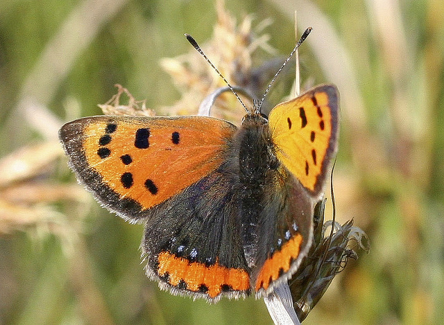
One advantage of submitting my data to the Data Centre is that all my records are stored in a database and I can map and query them online. I don’t have to worry about managing my own records, or making backups – all that is done for me. Looking back at my old records I notice that I observed a wall brown butterfly in my garden on 20 August, 2000. I have long since forgotten I had seen one in Kilkenny. Certainly I have not seen one since, as this is now a rare species in the county. I wonder have they become extinct in the county in the last 10 years?
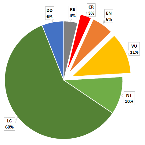
Collating historic records of this kind into different date periods allows us to detect if a species range has contracted or expanded over time. Using criteria developed by the International Union for Nature Conservation (IUCN) the risk of extinction faced by species can be assessed objectively. The process, known as Red Lists, has been completed for 10 taxonomic groups in Ireland and shows that on average, about 20% of species are threatened with extinction. For bees, such an important group that provide valuable pollination services, over 30% of species are threatened with extinction in Ireland. These are important, if not alarming, findings that should feed into policy to conserve biodiversity. On checking the Butterfly Red List I find that the wall brown is indeed, one of three species endangered with extinction in Ireland.
Monitoring biodiversity
I don’t have a great deal of time for scientific survey, but to make best use of the time available to me, I have signed up to walk a butterfly transect each week as part of the Irish Butterfly Monitoring Scheme. This gives me an excuse to get into the field, and I know that by walking the identical route, in a standard way on different dates, the data I collect is used to monitor changes in butterfly populations. For I am one of 120 recorders who contribute to make the Irish Butterfly Monitoring Scheme the largest citizen science insect monitoring scheme in Ireland. And thanks to our combined efforts the scheme can show categorically, for example, which years were good for butterflies and which were not, and over time between-year population variation can be separated from long-term population trends. And the European Grassland Butterfly Indicator has just been published by the European Environment Agency, so I have the satisfaction of knowing my sighing are contributing to policy formulation at both the national and European level.
Ecological modelling – the future of Atlas projects?
When I started recording a number of decades ago, the task was to cover as much ground as possible, recording as many species as possible. Now, with the greater power of statistical modelling, predictive models of the likelihood of encountering a given species based on partial, or incomplete data can be derived. In the very near future I am looking forward to participating in a recording scheme where distribution maps are generated by statistical modelling and my task will be to visit specific area not to derive a species list per se, but to confirm the prediction of which species should be present. It may take me some time to adjust to this new way of surveying but I will do it, as I will know that my recording effort will be far more efficient and the information generated far more valuable in the long run.